Saturday 26 March 2011

What is special about the Himalayas

The Himalayas is special for :
(1) Beautiful scenic mountains and landscapes that give a sense of SACREDNESS and has kept tourists visiting this "HEAVENLY" mountains all the year around; and
(2) The richness in its unexploited cultures and traditions that have been preserved...

Thursday 24 March 2011

Conservation Efforts to Preserve Majestic Himalayas

Saving the Himalayas


For the devout Hindus and Buddhists the Himalayas are the abode of gods; others see them as a snow-white mountain range of pristine beauty. The Himalayas also serve as the life line for the people in India, China and other countries in the region because the glaciers there are the largest store of water after the polar ace caps, feeding seven major rivers—the Ganga, Brahmaputra, Indus, Mekong, Thamlwin, Yangtze and Yellow River.

But in recent years, the Himalayas, famous for the highest peak in the world (Everest), have also earned a dubious reputation: the highest garbage ground on planet Earth.

According to the WWF, the Himalayan glaciers are melting fast. As a result countries like India, China and Nepal could expect to live through a cycle of floods followed by drought—both sources of untold miseries to people in a vast region.

It is believed that the Himalayan glaciers are retreating at the rate of 10-15 metres (33-49 feet) a year. The Gangotri glacier, source for the Ganga, is receding at the rate of 23 metres (75 feet) a year. Environmentalists warn that by 2025, the temperature on Earth could rise by 2 degree Celsius above the pre-industrial era level: a signal for trouble.

A concerned United Nations is setting up a task force that will investigate effects of climate change on the Himalayan (and other similarly threatened) region.

Climate change in regions like the Himalayas poses danger to nature and national and cultural heritage. The governments of member countries of the UN will be reminded of their legal obligations to cut greenhouse gas emissions, though with the worldâ™s most powerful country taking a defiant attitude towards controlling gas emissions the success of the UN mandate may be doubted.

The international community, however, is greatly worried about preserving the ecology of the Himalayas. The Sagarmatah (Nepalese name for Everest) National Park in Nepal has been put on the world heritage danger list. The question of saving the Himalayas has become a matter of uttermost importance. And appropriately enough, some of the leading mountaineers, many of whom had made it to the highest peak in the world, are now actively associating themselves with save Himalayas campaign

The Himalayas also feature a fragile ecosystem. For centuries, this ecosystem has remained delicately balanced, and has been responsible for the tremendous biodiversity of the Himalayas.

Only in recent years has the ecosystem been disturbed in various parts due to processes both man-made and natural.

Man has also been responsible to a large extent for some of the environmental problems faced by the mountains. As he strives for industrialization, modernization and the so-called higher standard of living, man has disturbed the natural ecosystems of many parts of the world.

The Himalayas have been no exception. Over the centuries, pilgrims and explorers have visited the mountains. However, in the past their numbers were few and the Himalayan ecosystem, fragile as it is, was able to cope with the effects of human exploration in the areas.

But today, the story is different. In the last few decades, an intricate network of roads have been built into the mountains, which have made some of the most remote areas more easily accessible. This has translated into a tremendous increase in the numbers of people who visit the mountains every year.

The Himalayas are now being exploited, to the hilt in many areas, to provide materials for the growing number of forest-based industries. Thus, it is not a surprise that environmental problems have emerged in the Himalayan region.


Courtesy : Syndicate Features

SAVE TIGER AWARENESS AS EDUCATION PROGRAM

17 June 2010, Chandigarh (India). Conservation Himalayas has strengthened its efforts to save Asian elephants and Bengal tigers in Uttarakhand State, India by carrying out a series of educational programmes.
To halt the loss of wildlife and forest biodiversity, and to celebrate the International Year of Biodiversity, the organization has installed Save-Tiger signage boards in the main tourist areas to raise public awareness of the tiger population in India, and has implemented three conservation educational programs

Program (1)
focused on the education of the poverty stricken, illiterate, labour class communities on tiger and elephant conservation.

Program (2)
titled Tiger Awareness Education, targeted school children as the pillar of nature protection. In 2010, nearly 120 children and 8 teachers of the Gyano Udaya Public School in Sanch village, Kotdwar participated in two events to celebrate the International Year of Biodiversity

Program (3)
aimed at the trainees of Corbett Wildlife Training Centre of the Corbett Tiger Reserve in Kalagarh, Pauri and the Nanda Devi Biosphere. In 2010, Conservation Himalayas engaged 45 trainees, working as foresters, in its two-day tiger training workshop. The workshop program consisted of practical training on the development of a tiger concept map, conservation strategies, and exercises on Tiger Survey – Field observation techniques


Friday 18 March 2011

The People in Nepal Himalayas

The way of life in the Himalaya is determined by the Himalayan topography, altitude, and climate, factors which quite substantially differ from region to region, plus, naturally, by the cultural diversity of the individual ethnic groups. Closer look at the variety of ethnic groups that populate this impressive mountain range reveals fascinating mix of architectural house styles.

Covered by lush monsoonal forests, the ridge of the Mahabharat range in the eastern Nepal separates the fertile lowland of Terai from “Limbuwan”, the Land of the Limbus. Poetically sited below steep hillsides of the Mahabharat Lekh or dotting the rolling land of the eastern Nepal Midlands, the dispersed villages of the Limbus are found between altitudes of 2,500 to 5,000 feet above sea level.  Traditionally also referred to by the Limbus themselves as the “Pallo-Kirant” or “Far-Kirant”, this region includes an area east of the Arun river and west of the Nepal-India border.
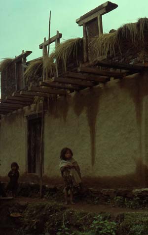
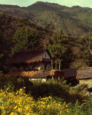
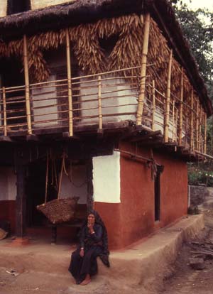
Limbu house surrounded by flowering mustard fieldsSited conventionally amid dry cultivated fields, the yards of the Limbu houses may often be beautified by planted beds of colorful flowers. The houses are built of stone, mud packed, and characteristically washed with white and ochre mud. Typically, each Limbu house has the same type of front elevation.  It is entered via a small porch, constructed like the balcony above it out of timber or bamboo.  Designed with a small window above the balcony, the roof is of a gable type.  Although in most instances the houses are roofed with thatch, the most prominent of the Limbus cover their houses with sun-baked shingles.  For the most part, there is not much variation in the design, although here and there one may come across interesting horn-like tiles extending upwards from the ends of the gable triangle, a feature reminiscent of the Far Eastern architecture.
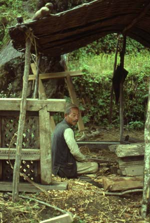
LimbusThe main living and sleeping area, including the kitchen hearth, is on the ground floor.  Grain, seeds, tools, and different sorts of family valuables are ordinarily stored on the second floor. Cattle is kept in shelters built in the vicinity of the house. Characteristic house type of the Limbus with bamboo balconyLocal carpenter making traditional window Limbu house under construction
The People of the Himalayas - the Sherpa of Nepal

History tells us that the original inhabitants of the Himalayas were the Kinnars, Kilinds, and Kiratas. Our Hindu epics and Puranas give reference of their existence in the Himalayan regions. History also mentions the names of Khasas and the Darads.


But today only three different ethnic groups form the Himalayan population. They are the Negroids, Mongoloids and the Aryans. The population, settlement in the Himalayan region is greatly influenced by the topography, economic pattern and the climatic condition.


The climate condition is one of the main factors for the population settlements since extreme climatic condition imposes a restriction on the living conditions and tends to restrict movement and communication. But the ethnic groups living in remote valleys of the Himalayan region have generally conserved their traditional cultural identities.

Sherpas -- The Tigers of the Mountains

Together with the brave Gurkha soldiers of Nepal, the Sherpas are among the most world-famous of Nepalese people. The world's highest-living population, the Sherpas are born mountaineers. It is their fantastic mountaineering prowess and their hardiness that brought them into prominence in mountaineering circles in the early parts of this century

The Sherpas originally came from eastern Tibet, crossing the Nangpa La pass at 5,900 m (19,100 ft) altitude about five centuries ago. They settled in the Khumbu region, the gateway to Mt Everest from the southern side. The word "Sherpa" literally means people from the east. Given their background, they practice the Tibetan form of Buddhism. Before coming into contact with western civilization, the Sherpas were simply farmers, yak herders and traders. They used to carry grains, cotton clothes, irons, paper from the south, and barter these for salt, wool, sheep and Tibetan artifacts in Tibet.


sherpa house

 For centuries, the Sherpas revered the great mountains of their region as dwelling places of gods and goddesses. The very thought of climbing them was considered blasphemous.

Mount Everest is known in Tibetan as Qomolangma or Chomolangma, meaning goddess mother. The Sherpas became famous as mountain climbers much before Sherpa Tenzing Norgay scaled Mt Everest along with Edmund Hillary in 1953. It was during the pioneering British expeditions in the early part of the century that the Sherpas rose to prominence.

During the first Everest expedition in 1921, the skill, expertise, honesty and dedication of the Sherpas impressed the English climbers. From that point on, the Sherpas became an integral part of international Himalayan climbing as guides and partners. The affinity of Westerners for the Sherpa/Buddhist civilization eventually grew into an increasingly close sharing, understanding and friendship between these two cultures. Interestingly, the close contact with Western thought and civilization did not affect the Buddhist, animist and cultural traditions of these people.


However, the arrival of Westerners changed the lifestyle of the Sherpas forever. The Western mountain expeditions brought not only fame, but also the allure of mountaineering fame. These factors combined to encourage the Sherpas to embrace mountain climbing as part of their own culture.

This was a radical change from their traditional roles as traders and farmers. While these ancestral roles remain a staple element of Sherpa life, the leading of climbs and treks has become a mainstay of their economy and made their lives easier.
The Solo Khumbu region is the home of the Sherpas.

 About 5,000 Sherpas reside here. In the last few decades, Sherpas have migrated to other parts of Nepal and the Indian states of Sikkim, Assam and northern West Bengal (Darjeeling). A total of about 35,000 Sherpas currently live in Nepal.

Flowers in the Himalayas


Thursday 17 March 2011

Natural Vegetation ...its Flower and Fauna

Vegetation
Himalayan vegetation varies according to both altitude and climatic conditions. They range from the tropical deciduous forests in the foothills, to temperate forests in the middle altitudes.


Himalayan Rainforest


Types of Himalayan Forests
The great Himalayas can be divided into three mountainous regions of Eastern, Central and Western Himalayas. The forests in these three regions are classified according to various factors such as composition of trees, elevation and rainfall.
The different types of Himalayan forests are Alpine Forests, Sub-tropical Rainforests, Deciduous Forests and Coniferous Forests

Himalayan Coniferous Forests


Coniferous Forests (Needleleaf Forests)Coniferous Forests are found between the elevations of 3000 m and 4,500 along total Himalayas and containing variety of wood species like Blue Pine, Deodar, Spruce and Silver Fir.

These forests can adapt severe freezing temperature of Himalayas with heavy snowfalls on winter days as they are having cone shape with needle like leaves.

Mostly these forests are lying just below the timber line of Himalayas.Timber line of the Himalayan forests usually lies at an altitude of 4000 m in Eastern Himalayas and the same lies at an altitude of 3500 m in Western ranges. However most parts of the Himalayas above 5,500 m are completely free from any vegetation

Alpine Forests
These are the ones lying between foot hills and timber line ( a line above which trees do not grow) of total Himalayas where we can find different wood species that we can find along Deciduous and Coniferous forests. In this region temperature is decreasing with increasing elevation.


<><>
<>
<><>
PineTrees in Himalayas


The vegetation also varies from the unexplored tropical rainforests of the Eastern Himalayas, to the dense subtropical and alpine forests of the Central and Western Himalayas to the sparse desert vegetation of the cold desert areas of the Transhimalaya.


However, the floral wealth of the Himalayas have also been affected by man. Over the centuries, man has always been dependent on his forests for a number of his needs. But earlier, these needs were few, the forests were able to replenish the resources, and the delicate natural balance was maintained. But over the years, the human population increased dramatically, and with it the number of industries that depended on forests.

Extraordinary demands were made on the forests. Forests were cut down for firewood and to feed the growing number of forest-based industries. They were also cleared to accommodate the growing population. As a result, many species of trees that were very common even 50 years ago, are now rare or have completely disappeared from certain areas

Birch trees Himalayas

Birch Trees in Western Himalayas
.

Wednesday 16 March 2011

Climatic Conditions in Majestic Himalayas

The Himalayas influences the climate of the Indian subcontinent by sheltering it from the cold air mass of Central Asia. 

The range also exerts a major influence on monsoon and rainfall patterns. Within the Himalayas climate varies depending on elevation and location. 

Climate ranges from subtropical in the southern foothills, with average summer temperatures of about 30° C (about 86° F) and average winter temperatures of about 18° C (about 64° F); warm temperate conditions in the Middle Himalayan valleys, with average summer temperatures of about 25° C (about 77° F) and cooler winters; cool temperate conditions in the higher parts of the Middle Himalayas, where average summer temperatures are 15 to 18° C (59 to 64° F) and winters are below freezing; to a cold alpine climate at higher elevations, where summers are cool and winters are severe. 


At elevations above 4880 m (16,000 ft) the climate is very cold with below freezing temperatures and the area is permanently covered with snow and ice. The eastern part of the Himalayas receives heavy rainfall; the western part is drier.


Himalayas at 4000 metres

Geologic Formation and Structure

  The Himalayan mountain system developed in a series of stages 30 to 50 million years ago. The Himalayan range was created from powerful earth movements that occurred as the Indian plate pressed against the Eurasian continental plate.


The earth movements raised the deposits laid down in the ancient, shallow Tethys Sea (on the present site of the mountains) to form the Himalayan ranges from Pakistan eastward across northern India, and from Nepal and Bhutan to the Myanmar (Burmese) border.

Even today the mountains continue to develop and change, and earthquakes and tremors are frequent in the area

The Himalayas are known to be youngfold mountains. Young, because these have been formed relatively recently in the earth's history, compared to older mountain ranges like the Aravallis in India, and the Appalachian in the USA. They are known as fold mountains because the mountains extend for 2500 km in length in a series of parallel ridges or folds.


the continents, 180 million years ago
 Around 200 million years ago (also known as the Middle Permian Period) , an extensive sea stretched along the latitudinal area presently occupied by the Himalayas. This sea was named the Tethys. Around this period, the super continent Pangea began to gradually split into different land masses and move apart in different directions.

As a result, rivers from both the northern Eurasian land mass (called Angara) and the southern Indian land mass (called Gondwana) started depositing large amounts of sediments into the shallow sea that was the Tethys. There were marine animals called ammonites living in the sea at the time. The two land masses, the Eurasian and the Indian sub-continent, moved closer and closer. Indian plate was moving north about at the rate of about 15 cm per year (6 inches per year).

the continents, 65 million years ago
The initial mountain building process started about seventy million years ago (or the Upper Cretaceous period) when the two land masses (or plates) began to collide with each other. As a result, the already shallow seabed rapidly folded folded and was raised into longitudinal ridges and valleys.

Although the phase of major upheaval of the Himalayas has passed, the Himalayas are still rising, albeit at a much slower rate. The Indian plate is continuously moving north at the rate of about 2 cms every year. Because of this reason the Himalayas are rising at the rate of about 5 millimeter per year.
The continents today.

This means that the Himalayas are still geologically active and structurally unstable. For this reason, earthquakes are a frequent occurrence in the entire Himalayan region.

Classification of the Himalayas

The great Himalayas, the highest mountain range in the world, extend along the northern frontiers of Pakistan, India, Nepal, Bhutan, and Burma. It spreads through the Continent of Asia. The Himalayan system, about 2,400 kilometers in length and varying in width from 240 to 330 kilometers, is made up of three parallel ranges--the Greater Himalayas, the Lesser Himalayas, and the Outer Himalayas--sometimes collectively called the Great Himalayan Range.

"Himalaya" is a Sanskrit word which literally means "Abode of Snow" - from hima, "snow," and alaya, "abode" - a term coined by the ancient pilgrims of India who travelled in these mountains. For Tibetans, Indians, Nepalese, and many of the other inhabitants of the Himalayas, the mountains continue to be the predominant factor in their lives. The beauty of the Himalayas has lured visitors to this region since olden times. And being the world's highest mountain chain, it constitutes the greatest attraction to climbers and trekkers throughout the world. But more than anything else, the Himalayas represent the awe-inspiring power, beauty, and grandeur of Nature. Welcome to the Himalayas - Where Earth Meets Sky!

Gurudogmar Lake at 17,200ft
in the Trans Himalayan region
of Sikkim, India.
Destination Himalayas - Where Earth Meets Sky offers an exploration of the Himalayas by region. It will take you across the vast Himalayas from one region to the next, exploring the unique beauty of each region.


Classification of the HimalayasFor a proper study, it is necessary to classify the vast area covered by the mountains into smaller sub-sections. Throughout our website, references will be made to these classifications.
The Himalayas can be classified in a variety of ways. From south to north, the mountains can be grouped into four parallel, longitudinal mountain belts, each with its unique features and distinctive geological history.

From west to east the Himalayas are divided broadly into three mountainous regions - the Western Himalayas, the Central Himalayas and the Eastern Himalayas.
Possibly the most important divisions of the Himalayas these days are the ones based on political boundaries. For anyone exploring the mountains, knowledge of the political boundaries is very important nowadays because most of the Himalayas lie very close to sensitive international border regions, many of which are disputed territories. Special permission is often required to visit certain areas close to the borders which are under military control due to their strategic importance. Based on international political boundaries, the Himalayas are divided into
Indian Himalayas

The arc-shaped Himalayas extend along the entire northern boundary of India and carve just as far across the Indian subcontinent as they do deeply into the life around them.

The term "Himalaya" -- a Sanskrit word meaning "the Abode of Snow" -- was coined by the Indian pilgrims who traveled in these mountains in ancient times. For centuries, the inhabitants of India have been fascinated by this mountain chain. The feeling is a mixture of admiration, awe and fear; and for the Hindus of India, the Himalayas are also "the Abode of God". There are numerous pilgrim routes that have brought the Hindu pilgrims to these mountains since time immemorial.

Extet of the Indian Himalayas
Extent of the Indian Himalayas.
Credit: Debangsu Sengupta

View Detailed Maps
Himalayan States  Himalayan Divisions

The Indian Himalayas cover a vast area along the northern frontiers of the country and span five Indian States -- Jammu and Kashmir , Himachal Pradesh, Uttar Pradesh, Sikkim and Arunachal Pradesh -- from west to east. For the mountain people living in these states, the Himalayas continue to be the predominant factor in their lives.

Having acted as a natural and political barrier for centuries, the Himalayas have isolated a number of communities, cultures and customs.

The Indian Himalayas mark the crossroads of Asia's three main religions. Kashmir -- formerly a paradise on earth -- is largely influenced by Islam.
The foothills of Jammu, Himachal Pradesh and Uttar Pradesh form the northern boundary of Hinduism. The entire Trans Himalayan region, from Ladakh (Jammu and Kashmir) through Tibet and onto the eastern state of Sikkim, has seen a dominating influence of Buddhism.


Nepalese Himalayas
Containing nine of the world's fourteen highest mountain peaks, Nepal is a true Himalayan kingdom. The Himalayas cover three fourths of the land in Nepal. It is home to some of the highest, remotest, most rugged and most difficult terrain in the world.

The loftiest peak in the world -- Mount Everest -- and other high peaks like Lhotse, Nuptse, Annapurna, Dhaulagiri and Manaslu, plus the presence of some exquisitely beautiful trekking routes, attract hundreds of thousands of people from all over the world to this lovely Himalayan destination.
The country of Nepal can be divided into three parallel bands running from the northeast towards the southwest.


Along the north of Nepal runs the Great Himalayan Range, the highest mountain range in the Himalayan system. This range has an average altitude of about 4,570 m (about 15,000 ft) and remains perpetually snow-covered. On this range rise some of the loftiest mountain peaks in the world -- Mount Everest, Kanchenjunga, Lhotse, Makalu, Cho Oyu, Dhaulagiri, Manaslu, and Annapurna.


Further south runs a complex system of intermediate ranges at an altitude of 8,000-14,000 ft. Prominent ranges in this mountain system include the Mahabharat and Churia ranges. High mountain ranges are interspersed with broad inhabited river valleys. The third and southernmost region is the Terai, a swampy terrain which is the northern extension of the Indian plains.


Sunset at Nuptse. Credit: Stan Armington
Sunset at Nuptse
Credit:
Stan Armington


Map of Nepal. Credit: Stan Armington

Tibetan Himalayas
Tibet is situated on the Qingzang (Qinghai-Tibet) Plateau. This is the highest plateau in the world with an average elevation of 4,875 m (more than 16,000 ft), and the Tibetan Plateau is also called the Roof of the World. In 1964, Tibet became an Autonomous Region of China. It is surrounded in the north and east by other provinces of China, in the south and west by Burma, India, Bhutan, and Nepal. The capital of Tibet is Lhasa.

Tibet is surrounded on three sides by vast mountain systems: the Kunlun mountains of Central Asia in the north, the Karakoram range in the west and the Himalayas in the south.

View from Pang La (pass) at 17,000 ft. Credit: W. Spiegelman
View from Pang La (pass) at 17,000 ft on the jeep road to the village of Kharta
in western Tibet. The panorama of the Tibetan Himalayas includes four of the
world's tallest mountains -- Makalu (far left), Everest and Lhotse (center)
and Cho Oyu (right) are all over 8,000 meters high.

Credit:
W. Spiegelman

Trans Himalayas
Tibet lies in a region known as Trans Himalayas. As the term suggests, Tibet lies beyond the main Himalayan range. The Trans Himalayan region itself is an ill-defined mountain region covering an area of about 1,000 km (600 miles) and having a width ranging from 225 km (140 miles) to about 32 km (20 miles). Unlike the main Himalayas, the Trans Himalayan mountains are not divided by deep river gorges. On the Roof of the World, passes average 5,330 m (17,500 ft) in height, with the highest being the Chargoding Pass at a height of 5,885 m (19,308 ft).

The first recorded European exploration of the Trans Himalayas was carried out by the Swedish explorer Sven Hedin. Hedin explored Tibet and the Xinjiang (Sinkiang) region extensively. He identified the sources of the Brahmaputra, Indus, and Satluj rivers, and, in 1906, explored and named the Kailas Range.


Everest panorama. Credit: W. Spiegelman
Everest panorama.
From left to right are Makalu and Chomolonzo,
Lhotse, Lhotse shar, and the Kangshung face of Mt Everest,
first climbed by an American team led by Lou Reichardt.

Credit:
W. Spiegelman

The southern part of Tibet falls within the Himalayan region. Some of the world's highest mountains define the southern border of Tibet. These include Mt Everest (8,848 m) -- the highest mountain in the world, Namcha Barwa (7,756 m / 25,445 ft) -- around which the Brahmaputra carves a fantastic gorge to enter India, and Gurla Mandhata (7,728 m / 25,355 ft). Running north of the main Himalayan range is the Kailas Range, named thus by Hedin.

The valley of the Tsangpo as seen from the Lhasa highway between Lhasa and Shigatse. Credit: W. Spiegelman
The valley of the Tsangpo as seen from the Lhasa highway,
between Lhasa and Shigatse. From here, the road continues
across western Tibet to the edge of the Tibetan plateau,
then drops thousands of feet down to the border with Nepal.

Credit:
W. Spiegelman

Between the two ranges lies the river valley region extending for about 1,000 km from west to east. The Brahmaputra River (known in Tibet as the Yarlung Tsangpo) flows from west to east through most of this region. The Tibetan plateau is the source of some of the biggest rivers in the Himalayas. The Brahmaputra, Indus and Satluj are three Trans Himalayan rivers that originate in Tibet, cut across the main Himalayas making fearsome gorges and then flow towards the plains.


Map of Tibet. Tibet is officially Tibet (Chinese Xizang) Autonomous Region, China.
Map of Tibet.
Tibet is officially Tibet (Chinese Xizang) Autonomous Region, China.
The great Himalayas, the highest mountain range in the world, extend along the northern frontiers of Pakistan, India, Nepal, Bhutan, and Burma

View of Himalayas from Space

View from space

The Himalayan system, about 2,400 kilometers in length and varying in width from 240 to 330 kilometers, is made up of three parallel ranges--the Greater Himalayas, the Lesser Himalayas, and the Outer Himalayas--sometimes collectively called the Great Himalayan Range.

Covering an astounding area of 612,021 sq. km, the vast mountain chain passes through the Indian States of Jammu and Kashmir, Himachal Pradesh, Uttar Pradesh, Sikkim and the Himalayan kingdoms of Nepal and Bhutan

Tuesday 15 March 2011

Location of The Himalayas


Himalayas
From Wikipedia, the free encyclopedia
Jump to: navigation, search
Himalayas
Range
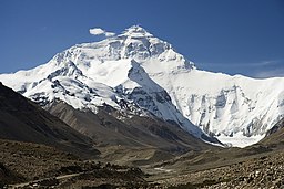
The north face of Mount Everest as seen from the path to the base camp in Tibet Autonomous Region, People's Republic of China.
Countries Bhutan,  People's Republic of China,  India,  Nepal,  Pakistan,  Burma,  Afghanistan
Highest pointMount Everest
 - elevation8,848 m (29,029 ft)
 - coordinates27°59′17″N 86°55′31″E / 27.98806°N 86.92528°E / 27.98806; 86.92528
The Himalaya Range or Himalaya Mountains
The great Himalayas, the highest mountain range in the world, extend along the northern frontiers of Pakistan, India, Nepal, Bhutan, and Burma. They were formed geologically as a result of the collision of the Indian subcontinent with Asia.